- Home
- Daily Field Report Report ID: 61276
- This project is inactive from admin. Download Report
Daily Field Report
Observations/Finding
The undersigned ASEC representative visited the Sherwood Square site to oversee and document the subsurface investigations conducted using hand augers.
Current Understanding of the Proposed Development:
The development plan involves the installation of a sanitary sewer forcemain along the east side of Spout Springs Road between Sta 0+00 and Sta 15+00. As part of the geotechnical investigation, fifty-nine (59) hand augers were executed to assess the subsurface conditions and provide design recommendations.
Test Procedures and Results:
A total of 59 hand augers were conducted along the proposed forcemain route. Each auger was advanced to a depth of 5 feet or until hand auger refusal, whichever occurred first. The results from these augers have provided insights into the subsurface stratigraphy, groundwater conditions, and potential rock outcrops.
Site Geology and Subsurface Conditions:
- Soil and Rock Stratigraphy:
- The predominant soil type encountered during the hand augering was brown, silty fine to medium sands with some clay at depths of 1-2 feet. This then transitioned to tan brown silty fine to medium sands interspersed with roots and rock fragments.
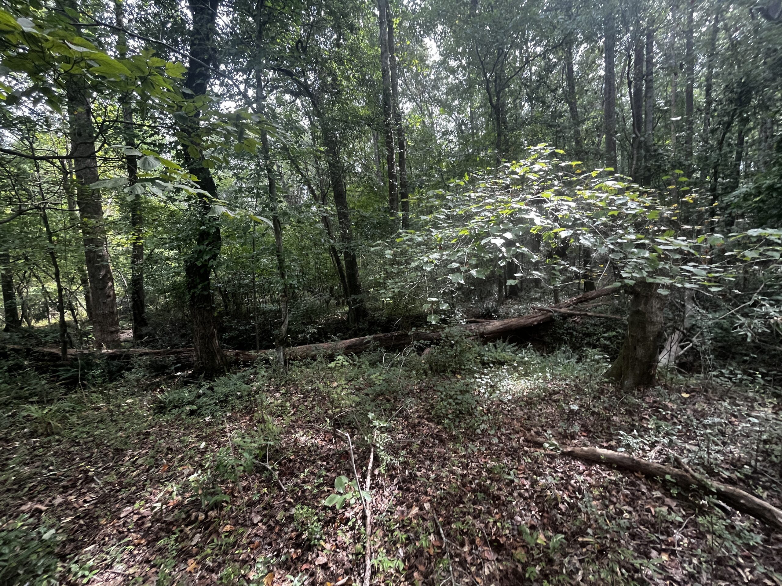
- Rock outcrops were observed in the creek bed, particularly between borings HA-16 and HA-28.
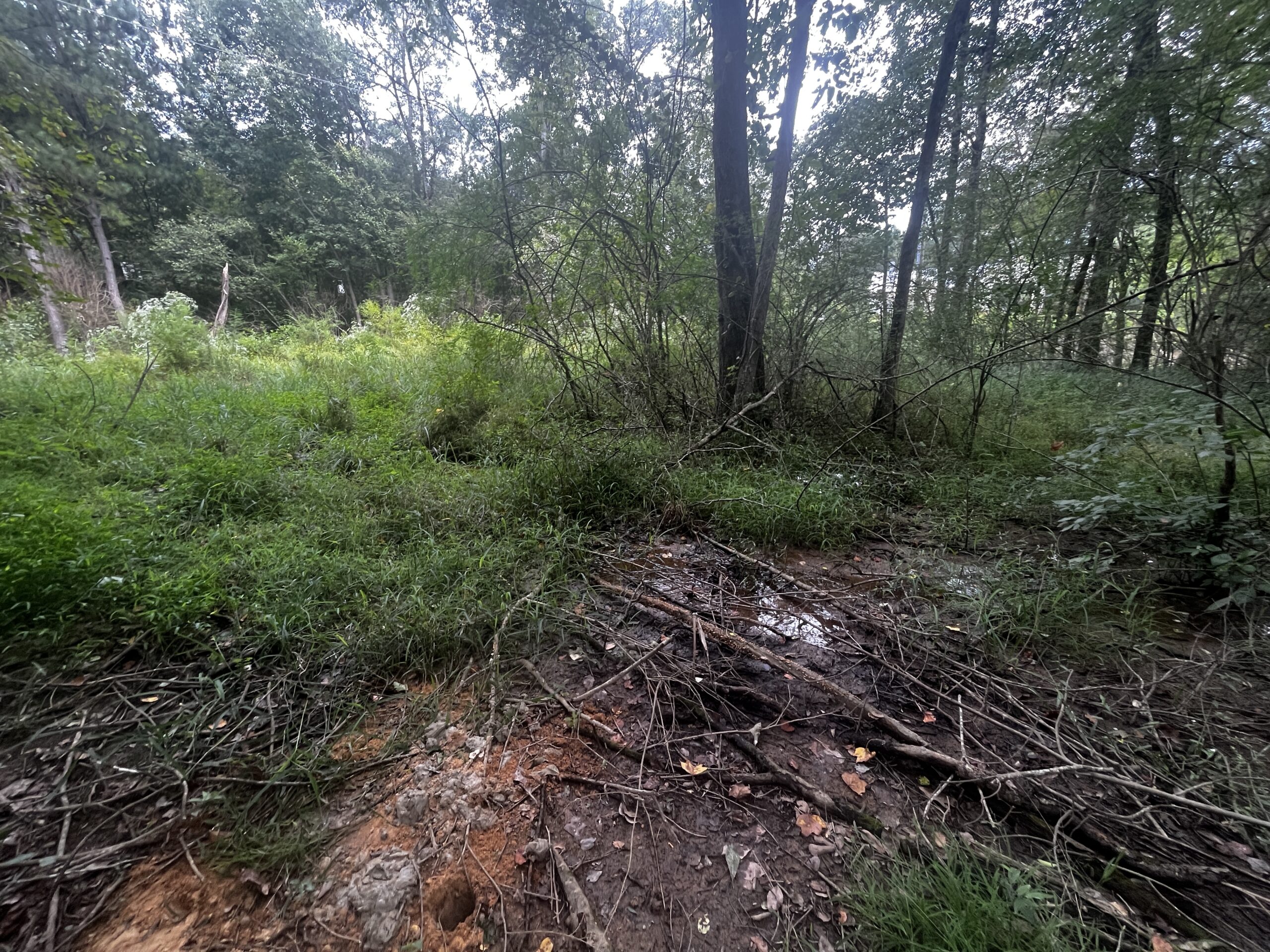
- Organic materials were encountered at deeper depths specifically for borings HA-53 to HA-59, where groundwater was intercepted.
- Groundwater Conditions: Groundwater was intercepted in borings HA-53 to HA-59. The wetland area, in particular, exhibited signs of groundwater influence, with hydrous soil conditions and visible oil sheens.
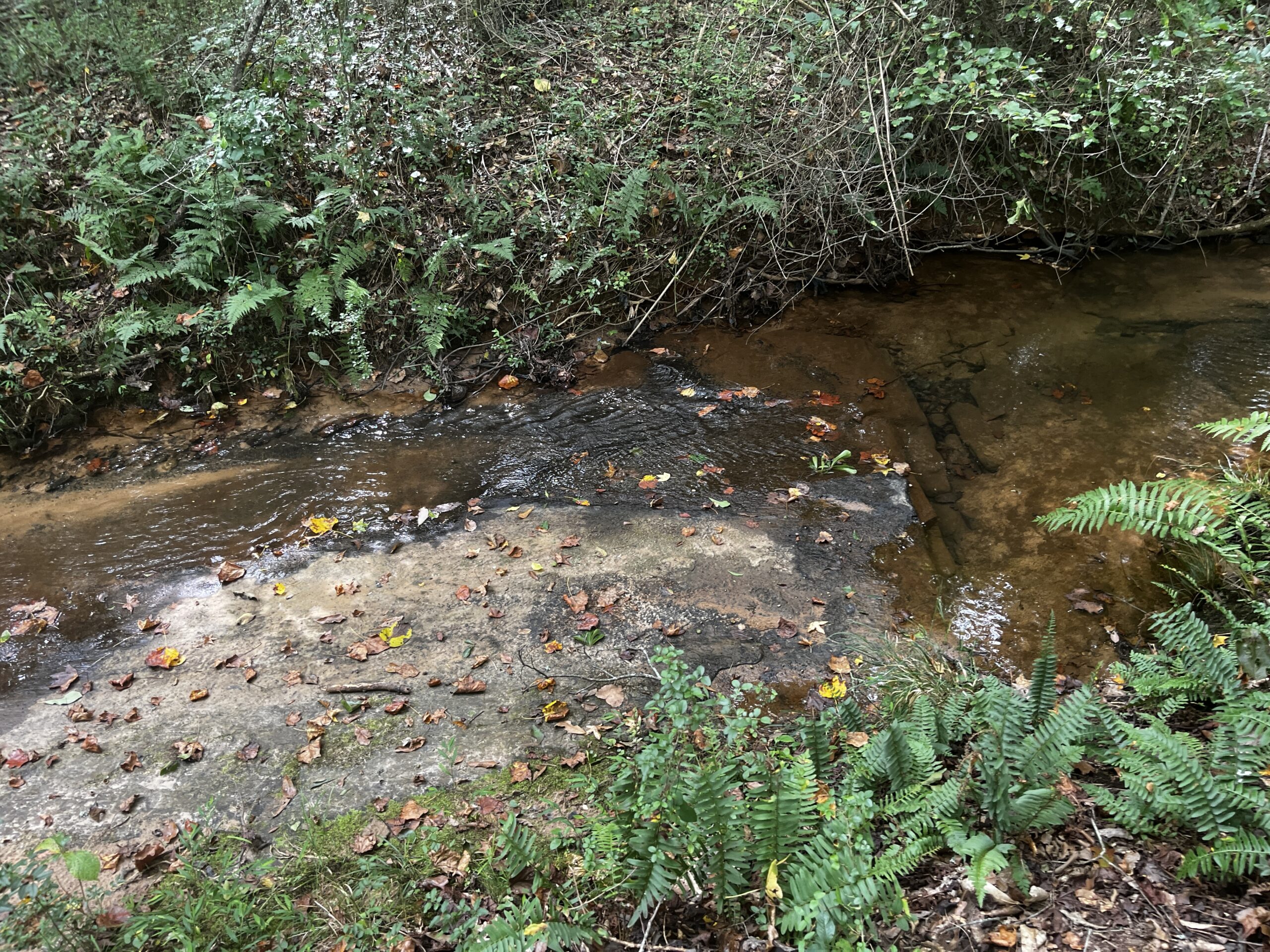
- Ecosystem and Creek Observations: Auger borings HA-05 to HA-28 are adjacent to a small creek that runs parallel with the road. The creek, which has an approximate depth of 3-4 feet, is situated about 15 feet below the road elevation. The creek bed consists of medium to coarse sands with gravel-sized rock in the section near borings HA-05 to HA-15. An outcrop of rock is present at the bottom of the creek bed between borings HA-16 to HA-28. The water in the creek was clear, and the ecosystem appeared stable, with many of the deeper pools containing small cichlids, indicating a healthy aquatic environment. Additionally, the trees lining the creek seem to play a crucial role in reducing erosion, especially during flash floods, thereby stabilizing the creek banks.
| Augar No. | Auger Refusal Depth (AR) | Offset | Soil Classification | Remarks |
| HA-01 | 2.5′ | 2’8″ | Brown Silty Sand | – |
| HA-02 | 2’9″ | 3′ (Towards Road) | Brown Silty Sand | Refusal at 3’7″ due to hard strata |
| HA-03 | 3’9″ | 5’2″ | Brown Silty Sand | – |
| HA-04 | 3’8″ | 5′ | Brown Silty Sand | – |
| HA-05 | 4′ | 3’5″ | Brown Silty Sand | Adjacent to creek |
| HA-06 | 4’8″ | – | Brown Silty Sand | – |
| HA-07 | 5′ | – | Brown Silty Sand | – |
| HA-08 | 5′ | – | Brown Silty Sand | – |
| HA-09 | 4’3″ | – | Brown Silty Sand | – |
| HA-10 | 2’8″ | 3′ (Towards Road) | Brown Silty Sand | Refusal at 3’4″ due to hard strata |
| HA-11 | 3’9″ | – | Brown Silty Sand | – |
| HA-12 | 4′ | – | Brown Silty Sand | – |
| HA-13 | 5′ | – | Brown Silty Sand | – |
| HA-14 | 2’7″ | 3’2″ | Brown Silty Sand | – |
| HA-15 | 3′ | 3’5″ | Brown Silty Sand | – |
| HA-16 | 2′ | 2’8″ | Brown Silty Sand | Refusal due to hard strata |
| HA-17 | 3’8″ | 2’6″ | Brown Silty Sand | Refusal due to hard strata |
| HA-18 | 3’6″ | 2’9″ | Brown Silty Sand | Refusal due to hard strata |
| HA-19 | 3’10” | 2’8″ | Brown Silty Sand | Refusal due to hard strata |
| HA-20 | 3’9″ | 2’7″ | Brown Silty Sand | Refusal due to hard strata |
| HA-21 | 3’7″ | 2’5″ | Brown Silty Sand | Refusal due to hard strata |
| HA-22 | 3’11” | 2’9″ | Brown Silty Sand | Refusal due to hard strata |
| HA-23 | 4′ | 2’8″ | Brown Silty Sand | Refusal due to hard strata |
| HA-24 | 3’8″ | 2’6″ | Brown Silty Sand | Refusal due to hard strata |
| HA-25 | 3’9″ | 2’7″ | Brown Silty Sand | Refusal due to hard strata |
| HA-26 | 4’1″ | 2’9″ | Brown Silty Sand | Refusal due to hard strata |
| HA-27 | 3’10” | 2’8″ | Brown Silty Sand | Refusal due to hard strata |
| HA-28 | 3’8″ | 2’6″ | Brown Silty Sand | Refusal due to hard strata |
| HA-29 | 4′ | 2’8″ | Brown Silty Sand | Refusal due to hard strata |
| HA-30 | 3’7″ | 2’5″ | Brown Silty Sand | Refusal due to hard strata |
| HA-31 | 3’9″ | 2’7″ | Brown Silty Sand | Refusal due to hard strata |
| HA-32 | 3’11” | 2’9″ | Brown Silty Sand | Refusal due to hard strata |
| HA-33 | 3’6″ | 2’4″ | Brown Silty Sand | Refusal due to hard strata |
| HA-34 | 4′ | 2’8″ | Brown Silty Sand | Refusal due to hard strata |
| HA-35 | 3’8″ | 2’6″ | Brown Silty Sand | Refusal due to hard strata |
| HA-36 | 3’10” | 2’8″ | Brown Silty Sand | Refusal due to hard strata |
| HA-37 | 3’9″ | 2’7″ | Brown Silty Sand | Refusal due to hard strata |
| HA-38 | 5′ | – | Brown Silty Sand | – |
| HA-39 | 4’6″ | – | Brown Silty Sand | – |
| HA-40 | 4’8″ | – | Brown Silty Sand | – |
| HA-41 | 4′ | 2’8″ | Brown Silty Sand | Refusal due to hard strata |
| HA-42 | 4’2″ | 2’10” | Brown Silty Sand | Refusal due to hard strata |
| HA-43 | 3’9″ | 2’7″ | Brown Silty Sand | Refusal due to hard strata |
| HA-44 | 4′ | 2’8″ | Brown Silty Sand | Refusal due to hard strata |
| HA-45 | 3’11” | 2’9″ | Brown Silty Sand | Refusal due to hard strata |
| HA-46 | 4’1″ | 2’11” | Brown Silty Sand | Refusal due to hard strata |
| HA-47 | 4′ | 2’8″ | Brown Silty Sand | Refusal due to hard strata |
| HA-48 | 3’10” | 2’8″ | Brown Silty Sand | Refusal due to hard strata |
| HA-49 | 4’3″ | 2’11” | Brown Silty Sand | Refusal due to hard strata |
| HA-50 | 4′ | 2’8″ | Brown Silty Sand | Refusal due to hard strata |
| HA-51 | 4’2″ | 2’10” | Brown Silty Sand | Refusal due to hard strata |
| HA-52 | 4′ | 2’8″ | Brown Silty Sand | Refusal due to hard strata |
| HA-53 | 5′ | – | Brown Silty Sand with Organic Material | Groundwater Encountered |
| HA-54 | 5′ | – | Brown Silty Sand | Groundwater Encountered |
| HA-55 | 5′ | – | Brown Silty Sand | Groundwater Encountered |
| HA-56 | 5′ | – | Brown Silty Sand | Groundwater Encountered |
| HA-57 | 5′ | – | Brown Silty Sand | Groundwater Encountered |
| HA-58 | 5′ | – | Brown Silty Sand | Groundwater Encountered |
| HA-59 | 5′ | – | Brown Silty Sand with Organic Material | Groundwater Encountered |